The tilt of the Earth's crust governed ancient mega-floods
Ice age topography would have been different on broad scales due to deformation of the Earth's crust by the weight of ice sheets , new research reveals.
During the height of the last ice age, large ice sheets covered much of North America. They began to melt after about 20,000 years ago , with the Missoula Megafloods occurring between 18,000 and 15,500 years ago.
The investigation
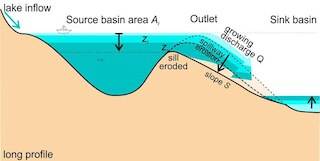
A team led by Tamara Pico, an assistant professor of Earth and Planetary Sciences at UC Santa Cruz, studied how the changing weight of ice sheets during this period would have tilted the topography of eastern Washington state, changing the amount of water that would flow into the different channels during floods . It publishes results in the Proceedings of the National Academy of Sciences.
Glacial Lake Missoula was formed in western Montana when a lobe of the Cordilleran ice sheet dammed up the Clark Fork valley in the Idaho fringe and meltwater pooled behind the dam. Eventually the water became so deep that the ice dam began to float, resulting in a glacial flood . After enough water was released, the ice dam was reset and the lake refilled. This process is believed to have been repeated dozens of times over a period of several thousand years.
Downstream of Glacial Lake Missoula, the Columbia River was dammed by another lobe of ice, forming Glacial Lake Columbia. When flash floods from Lake Missoula poured into Lake Columbia, the water spilled south onto the Eastern Washington Plateau, eroding the landscape and creating the so-called Channeled Scablands.

A different landscape
During this period, deformation of the Earth's crust in response to the growth and shrinkage of ice sheets would have changed the elevation of the topography by hundreds of meters, Pico said. His team incorporated these changes in flood models to investigate how the tilt of the landscape would have changed the path of mega-floods and their eroding power in different channels.
"We used flood models to predict the speed of water and the power of erosion in each channel, and compared that to what it would take to erode basalt , the type of rock in that landscape," Pico said in a statement.
They concentrated on two main canal systems, the Cheney-Palouse and Telford-Crab Creek reaches . Their results showed that earlier floods would have eroded both reaches, but subsequent floods would have concentrated flow in the Telford-Crab Creek system.

Native tribes
"As the landscape sloped, it affected both where the water overflowed from Lake Columbia and how the water flowed in the canals, but the biggest effect was the overflow in those two reaches," Pico said. "What's intriguing is that topography isn't static, so we can't just look at today's topography to piece together the past ."
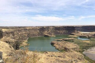
The findings provide a new perspective on this fascinating landscape, he said. Steep canyons hundreds of feet deep, dry falls, giant potholes, and ripple marks are among the many notable features etched into the landscape by the massive floods.
"When you're there in person, it's crazy to think about the magnitude of the flooding required to carve out those canyons , which are now dry," Pico said. "There are also huge dry waterfalls, it's a very striking landscape."
He also noted that the oral histories of Native American tribes in this region include references to massive flooding . "Scientists were not the first people to observe this," Pico said. "People may have even been there to witness these floods."
Comments